
|
|
||||||||||||||||||


| 2026-2027 Electoral Calendar, latest official version |

|
 |
|
|
|
|
|
|
|||||||
|
|
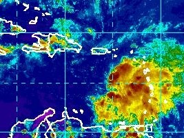
Haiti - Environment : First effects of Chantal tomorrow afternoon
Tropical Storm Chantal, is currently at 15.2N 63.7W, or 440 km southeast of San Juan, Puerto Rico, 763km east southeast of Santo Domingo and 994km east south-east of Port-au-Prince. Chantal moves at a speed of 43km/h West North-West, with maximum sustained winds of 100km/h, with higher gusts. These winds are confined to a small area east of the center. Chantal should be near hurricane strength before reaching Hispaniola. Tropical storm force winds extend outward up to 150 west of the center. This general motion is expected to continue for the next couple of days with a gradual decrease in the forward speed. on the forecast track... The center of chantal will continue to move away from the lesser antilles tonight... And is expected to be near or over the dominican republic by wednesday afternoon. Chantal should be on Haiti Wednesday during the afternoon, early evening. Chantal is expected to be over the southeastern and central bahamas on thursday. Haiti is in the alert phase at Vigilance Orange face the threats of Storm for all regions of Haiti, from Fort-Liberté to Môle Saint-Nicolas and the rest of the country in relation to conditions of heavy rain with risk of rockfalls, landslides and flooding from Wednesday night. The National Meteorological Center (CNM) in conjunction with the SPGRD and the DPC asking the population of areas at risk to remain vigilant and strictly implement the following safety precautions in case of flooding, rockfalls, landslides and thunderstorms. - Inform yourself on the weather, if you and your activities are in a zone prone to flooding and landslides (seaside, gullies, rivers, mountain slopes, etc...) - Be very careful near rivers during heavy rains, do not cross them under any circumstances. - In case of severe storms, do not shelter near windows and wooded area. HL/ HaitiLibre
|
|






|
|
Why HaitiLibre ? |
Contact us |
Français
Copyright © 2010 - 2026 Haitilibre.com |