
|
|
||||||||||||||||||


| 2026-2027 Electoral Calendar, latest official version |

|
 |
|
|
|
|
|
|
|||||||
|
|
Haiti - FLASH : Storm Franklin will affect Haiti
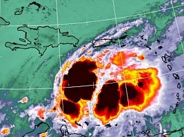
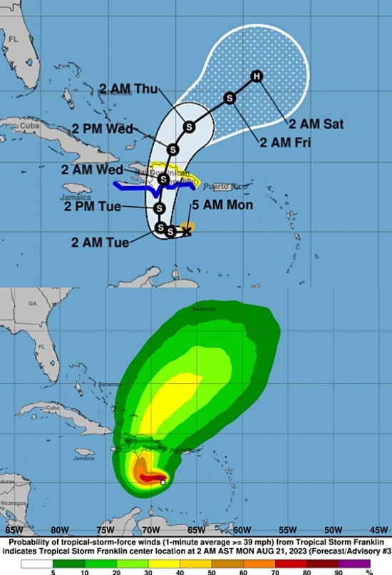
On Sunday August 20, Tropical Storm Franklin formed in the Caribbean Sea. This Monday, August 21 morning at 5:00 a.m. it was located at 15.0° North 69.2° West, the center of the storm is located 380km south of Santo Domingo and 505km southeast of Port-au-Prince. Tropical Storm Franklin is moving west-northwest at nearly 12 mph (19 km/h). A West to West-North-West track should continue today. A sharp northerly turn is expected tonight or early Tuesday, and a generally northerly move is expected on Tuesday. On the forecast track, the center of Franklin should reach the south coast of the island late Tuesday. Maximum sustained winds are near 80 km/h (50 mph) with higher gusts. Some reinforcement is expected before Franklin reaches the island. Tropical storm-force winds extend outward up to 95 km from the center. A tropical storm warning is in effect for the Dominican Republic along the entire south coast and eastward to Isla Saona; A tropical storm warning is in effect for Haiti along the entire south coast from Anse d'Hainault east to the Dominican border.
Franklin is expected to produce rainfall amounts of 5 to 10 cm (2 to 4 in), with higher isolated amounts of 12 to 25 cm (5 to 10 in), with higher isolated amounts up to 38 cm (15 po), will be possible in some parts of the island. Tropical storm conditions are expected to begin in the warning zone on Tuesday and in the watch zone from Tuesday evening. Franklin will raise water levels to 30 to 90 cm (1 to 3 feet) above sea level along the coast in the immediate vicinity of where the center will touch the coast of the island HL/ HaitiLibre
|
|






|
|
Why HaitiLibre ? |
Contact us |
Français
Copyright © 2010 - 2026 Haitilibre.com |