
|
|
||||||||||||||||||


| Download the revised decree and electoral calendar, published in the official journal |

|
 |
|
|
|
|
|
|
|||||||
|
|
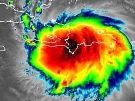
Haiti - FLASH : Laura, 2 million people could be affected 23/08/2020 05:53:07
This Saturday morning at 5:00 a.m., the center of Tropical Storm Laura was located near latitude 18.8 north and longitude 70.9 west. Laura is moving west-northwest at nearly 30 km/h (18 mph), and this general movement is expected over the next few days. The center of Laura is forecast to cross Hispaniola today, is currently 122km southeast of Hinche, will be near or over Cuba tonight and Monday, and over the southeastern Gulf of Mexico on Monday evening. and Tuesday. Maximum sustained winds are close to 75 km/h with higher gusts. No significant change in force is expected over the next 36-48 hours as Laura moves over or near Hispaniola and Cuba. Reinforcement is expected once Laura travels to the Gulf of Mexico on Monday evening and Tuesday. Tropical storm force winds extend outward up to 220 km from the center. Heavy rains and strong winds began on the night of August 22 and will continue throughout the day on Sunday, with a high probability of flash floods, floods and landslides including in urban areas. It is estimated that 2 million people could be affected by the heavy rains, reaching 200mm in some parts of the country. According to the Hydrometeorological Unit (UHM), the departments most exposed to heavy rainfall would be the South-East and the North-West. According to OCHA's analysis, the departments of the West and the South as well as certain communes of the Department of Artibonite could also be at risk. The General Directorate of Civil Protection (DGPC) has activated the National Risk and Disaster Management Plan with an "orange" alert level. Humanitarian partners are preparing to respond to potential impacts, under the leadership of Haitian authorities. The storm should pass fairly quickly over Haitian territory. HL/ HaitiLibre
|
|






|
|
Why HaitiLibre ? |
Contact us |
Français
Copyright © 2010 - 2026 Haitilibre.com |